Sunday

Miata Top Transitions since 10/24/08: 1475


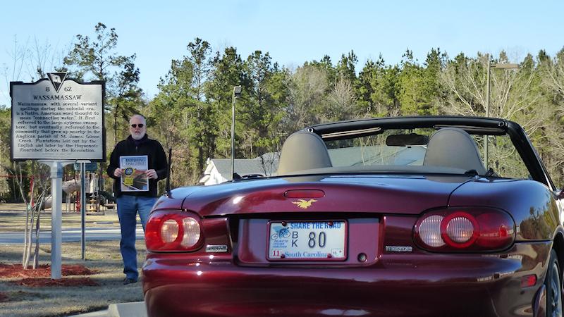
One of the “destinations” in this year’s Motoring Challenge is a palindrome sign and it is worth 2 points vs. the usual one. This was today’s road trip objective. According to Wikipedia’s page listing palindromic locations we are fortunately within driving distance of one of the three 2nd longest places that are spelled the same forwards and backwards, the 11 letter long Wassamassaw.
Historical Marker text:
(Front)

Wassamassaw, with several variant spellings during the colonial era, is a Native American word thought to mean “connecting water.” It first referred to the large cypress swamp here, but eventually referred to the community that grew up nearby in the Anglican parish of St. James, Goose Creek. Plantations laid out by the English and later by the Huguenots flourished before the Revolution.
(Reverse)
The swamp was almost impassible for most of the colonial period, but the Wassamassaw Road ran just below the swamp between here and Goose Creek. A Chapel of Ease was built nearby shortly after the Yamasee War of 1715, and a free school was founded in 1728. The “Wassamassaw Cavalry,” a militia company founded in 1857, later saw Confederate service as Company D, 2nd S.C. Cavalry.
Of all the entries in the 2015 Challenge for this destination, the best anyone can do is tie us when it comes to length by getting some other variation of Wassamassaw (there is a Baptist Church behind me and then there is a road by that name a few miles away near Summerville) or Ekalaka Lake in Montana. The only longer palindrome named place is Nerren Nerren at 12, but I doubt any Challengers will get it as it is in Western Australia.
On our Christmas Day road trip, we stopped at a convenience store at the crossroads of No and Where for a snack and a restroom break. I opened the door to the single toilet Men’s Room and there was already someone in there, so I backed out saying I’m sorry. As I played back the scene in my mind’s eye, I realized he wasn’t going to the bathroom, he was dropping quarter’s in the condom machine.
I cooled my heels, inventorying the Lance crackers on a rack a few feet from the door, waiting for the guy to finish his “business” in there. As he walked by, tucking a small packet into his jacket’s inside pocket, I asked, “Going to get your Christmas present?” He shrugged and replied, “I hope so.”

The last picture taken on our 2-Day Moss Motoring Challenge Photo Excursion is the above photo. We snapped a total of 48 photos and accomplished 9 objectives worth 11 points altogether. We traveled a little over 600 miles on 2 tanks of gas. We had breakfast at home on Christmas morning and dinner at home today. In between we had a picnic lunch next to the Flat Creek Quick Stop, a Chinese buffet for Christmas dinner, breakfast at DD and pizza with my sister at One West in Hendersonville.
Now all that remains is taking the photo that will be the one that is closest to home, something less than a mile away, something we have already taken a photo of nearly 10 months ago and are slightly unhappy with, a Horse Track. Once we get that picture we will have scored 125 points out of a possible 201.

Donna flew down last Sunday to spend some more time with her sister. I drove the Sonata down to Florida yesterday. This is a couple of firsts (for a while) as we can’t really remember the last time Donna flew on a commercial airplane* without me sitting next to her and the first time we have spent more than 5 nights apart since 1983. This is also the first time I’ve driven that far without her sitting next to me since way back when we first knew each other back in 1976.
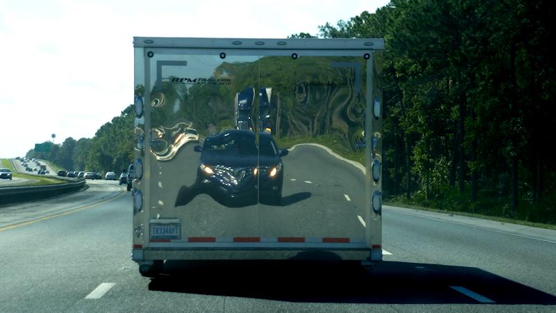
Kids, don’t try this at home, somewhere on I-95 I caught up to a shiny trailer hauling who knows what and thought that maybe I should take one hand off the steering, root around in the center console, find my camera, pull it out and press some buttons while driving at 80 MPH.
*She did fly on a couple of military hops to visit me once while I was on Guam before her (back in 1976 too.)
 It is actually fall around here, so for my birthday we were going to drive down to Folly Beach in an attempt to get a Moss Motoring Challenge photo of their fishing pier and to get some seafood for lunch on the beach.
We started our road trip today in the usual way, by going to the local DD and getting my coffee and Donna’s hot chocolate, when we left the parking lot it got slightly unusual. It was early, so there was very little traffic on the 5 lane Whiskey Road and it was still dark, so picking the spot to exit was easy. I waited out the two cars coming from the left that were close together and there were two more coming from the right that had a enough separation to get between, so I swung left, out between them and got in the far right lane because I was turning right at the next intersection about 200 yards away.
As I stopped at the light and prepared to make a right on red, that second car that I had got in front of, pulled to a stop behind me. It was a white car and I instantly recognized the headlight signature as that of a Dodge Charger, which probably meant one thing, city cop.
My blinker was on and the car behind me put his on. I turned right and moved to the left turn lane in preparation for my next turn. Sure enough the white Charger followed in step and when he got in the left lane, he lit ’em up. I hung another left into the back parking lot of the quick oil change place there.
We were in the Miata with the top down and as the officer approached the car, Donna “helpfully” told him it was my birthday and it was her fault we were going this way as she forgot something at home. I think our LEO was more nervous than I was because as he tried to explain why he was pulling me over he was stumbling over his sentences and was a little confused as to where I came from when I got on Whiskey Rd. He did get out that the reason we were gathered here together was that when making a left turn onto a multi-lane road you should enter the leftmost lane first before moving into the right one.*
I handed him my license, insurance card and registration and as he walked back to his car he said, “If everything checks out OK, I’ll probably send you on your way.” Well, of course everything checked out, so our friendly young officer reiterated why he pulled my over, then explained he was just giving me a warning, which generated the piece of paper he was giving me. He then wished me a Happy Birthday, told me to drive safe and sent me on my way.
I blurred out my driver’s license number in the image above (I didn’t do any of the rest of the info as it is already readily available elsewhere on this site.) I did change the name of our police officer** and blurred out his badge number as well.
*South Carolina Code of Laws, SECTION 56-5-2120. Required position and method of turning. Paragraph (b), Left turns … Whenever practicable the left turn shall be made to the left of the center of the intersection so as to leave the intersection or other location in the extreme left-hand lane lawfully available to traffic moving in the same direction as the vehicle on the roadway being entered. I’m guessing that if I was to get a ticket it would be for a violation of that bit of very confusing legalese. It is the only thing in the vehicle code that I can find that is remotely on point.
**to the first name that popped into my head, it’s from West Side Story in case you were wondering.
The Sunday before last on our way to Palm City we stopped for lunch at a Carrabba’s in Jacksonville. Donna had a series of coupons from a newspaper awhile back that were 2 for $10 off two dinners and in the middle was a $5 off two lunch entrees. We thought we’d use the lunch coupon, but as it turns out, there is no lunch menu on Sunday. Not a problem, we could just use one of the $10 dinner coupons. Figuring we would not use the other dinner one before it expired, Donna gave it away to a couple that was at a table near us.
We usually come back from FLA and stop near Ocala which is about halfway home. This time, because the University of Florida had a home football game, the usual Hampton Inn we stay at for $98 was charging a hundred bucks more. So last Saturday and instead of coming back up the Turnpike like we usually do, we opted to go straight up I-95. This put the halfway point on the southeast side of Jacksonville’s outer loop. I found a Hampton Inn there for a mere $75. When we were checking in, Donna asked the lad behind the desk if there were any restaurants within walking distance. He mentioned three, one of which was a Carrabba’s.* Because Donna really likes their Mama Mandola’s Sicilian Chicken Soup and I’m easy, that is where we went for dinner. Guess we should have kept that other $10 dinner coupon.
It was a lot busier on a Saturday evening compared to a Sunday lunch, but fortunately it was still early enough that there wasn’t any real wait for a place to sit. We couldn’t get a booth of course, but ended up in a half booth right next to a family that had a baby in a stroller between their table and ours. We both thought to ourselves, “Uh oh,” but they had just got their check so we knew it would be OK. As they were leaving, the woman leaned over to Donna and handed her a piece of paper and asked if we wanted it. It was a coupon for $10 off two dinner entrees…
*Not the same one as last week, that was on the north side of town.